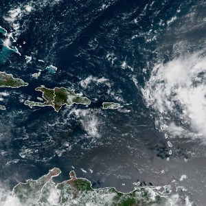
Hurricane Erin has officially kicked off the 2025 Atlantic hurricane season, forming early Friday morning. Tropical storm watches are in place for parts of the northern Leeward Islands, as reported by the National Hurricane Center (NHC).
Emerging in the eastern Atlantic Ocean, Erin is gaining strength while heading west. There is some uncertainty about its potential impact on areas like Florida and the Bahamas, but meteorologists are confident it will be a large, powerful storm this weekend.
Current Location and Path of Hurricane Erin
As of 5 p.m. ET Friday:
- Erin is located 365 miles east of the northern Leeward Islands.
- The storm has maximum sustained winds of 75 mph.
- It is moving west-northwest at 17 mph.
Forecasters expect Erin to continue this path into the weekend, likely moving just north of the northern Leeward Islands and Puerto Rico. Heavy rainfall is expected in these areas starting tonight, with rain totals predicting between 2 to 4 inches, and up to 6 inches in some spots. This could lead to flash flooding and mudslides.
On a positive note, the chances of direct impacts on the U.S. East Coast and the Bahamas are reported to be decreasing.
Will Erin Strengthen?
Experts believe Erin will likely strengthen over the next few days. A tropical storm becomes a hurricane when winds reach at least 74 mph. They rate hurricanes on the Saffir-Simpson Scale, which categorizes them from Category 1 (least severe) to Category 5 (most severe). If Erin continues to intensify, it could reach Category 3 status, requiring significant preparedness levels.
Watches and Warnings
Currently, tropical storm watches are in effect for:
- St. Martin
- St. Barthelemy
The NHC warns that tropical storm conditions could arrive in these areas by early Saturday.
How is This Hurricane Season Shaping Up?
This year’s hurricane season runs from June 1 to November 30, with a forecast indicating a 50% chance of above-normal activity. Last week, the National Oceanic and Atmospheric Administration (NOAA) estimated 13 to 18 storms. Historically, an average season sees 14 named storms. We’re now halfway, with six named storms already recorded, including Erin.
Social media has been buzzing with discussions about Erin. Many users are sharing safety tips and updates, showcasing the community’s focus on preparedness. In 2020, a record 30 named storms occurred, which illustrates how unpredictable hurricane seasons can be. Keeping informed is crucial.
In summary, Hurricane Erin is a significant early player in this season’s storms. Everyone in affected regions should stay alert and prepared. For the latest updates, check out the NHC’s official website.
Source link
Hurricane Erin, Atlantic Ocean, National Hurricane Center, hurricane season, tropical storm, major hurricane, forecasters, maximum sustained winds, Leeward Islands, Tropical Storm watches, 2025 Atlantic hurricane season


